Accessible walks for all fitness levels, from his book, The Walking Effect …

DJOUCE, CO WICKLOW
DISTANCE: 14km
DIFFICULTY: Easy to moderate
TIME: 1.5-4 Hours
This hike has a special place in my heart. When I was in first year in college, a family friend took me here and it was one of those moments that really kick-started my whole journey into fitness and endurance events. I struggled that day, but went back each Sunday until it got easier, and eventually started running it. Djouce once formed part of the Powerscourt Estate, a property with numerous roads and drives back in the day, including Lady’s Drive and Earl’s Drive, that now form part of the forest trail and road network. Views from Djouce include the Dargle River valley and Powerscourt Waterfall, the highest waterfall in Ireland and Britain. Djouce Mountain (725m) lies to the south west in the Wicklow Mountains National Park, and it is along the Wicklow Way.
There are two walking trails to explore at Djouce. The Blue Loop (4.5km, 1.5 hours, easy) follows one of the old driving roads where you get occasional views over to the deer park and the Powerscourt Waterfall. The Deerpark loop (9km, 3 hours, moderate) takes in the Paddock Ponds, which were a water source for the renowned Powerscourt fountains. It also gives you panoramic views over the Sugarloaf, Bray, Killiney Hill and Dublin Bay to Howth and along the Wicklow Mountains. The routes from the car park are trail marked with signposts, and it’s a really great place for families too.
SEE MORE: 5 Tasty Sandwiches To Try Around Ireland

BALLYVAUGHAN WOOD LOOP, CO CLARE
DISTANCE: 8km
DIFFICULTY: Easy
TIME: 2 Hours
The walk at Ballyvaughan Wood takes in of minor roads, surfaced and sandy roads, green lanes, lush woodland and cross-country terrain. Generally, you’ll be able to walk it in runners or trail shoes, but on a very rainy day or if the ground is wet you should put on your boots. Starting at Ballyvaughan’s seafront, the walk will take you past thatched cottages, over bridges and stiles, through open fields and farmland, and – at the midpoint – leads you by Aillwee Caves.
These are the Burren’s most well known ancient marvels. They boast more than 1km of passages leading into the heart of the mountain, as well as enormous stalagmites and stalactites. You can go for a guided tour if you’d like a break during your walk. Then back on the road and follow the trails back to Ballyvaughan village where you can enjoy some well-deserved refreshments.
SEE MORE: A Glossy Guide To Holidaying In Co Clare

ALLIHIES, CO CORK
DISTANCE: 7km
DIFFICULTY: Moderate
DURATION: 2-3 Hours
The colourful village of Allihies is the perfect base for exploring some of West Cork’s best walking routes, and this one, which sweeps in a loop around the coast, doesn’t disappoint. Bird-flecked cliffs, rocky fields, crashing waves and vast sea views mark the coastal part of the walk, which then detours inland. Passing farm buildings, the route climbs up into the disused Mountain Mine area, which reveals Allihies’ past as a copper-mining hub in the nineteenth century. Keep going and you’ll eventually loop back to the village, where music, food and pints await inside the bright red O’Neill’s Bar & Restaurant.

CONG WOODS, CO MAYO
DISTANCE: 6km
DIFFICULTY: Easy
TIME: 1.5 Hours
This is a really lovely, easy walk suitable for all the family. Starting at the church car park, enter the Cong Abbey grounds across the road and walk through the yew grove on the grounds. Cross the Cong River on the small stone bridge, the Abbey Bridge. At the far side of the bridge, you will enter the forest through a stone gateway. Turn left along the path for about 200 metres. Then turn right and follow the nature trail markers.
At the finger sign for Teach Aille (Cliff House in English), turn right and go down into the cave site. Steps beside the cave lead to higher ground above the cave. Follow the marked trail to a junction. Here, turn left under a viaduct, which is on the Cong/Cornamona road. Proceed along the trail to an old disused house on your left. Turn right here and walk towards Pigeon Hole Cave. There are steps down into the cave, where you can see a stream that flows underground from Lough Mask into Lough Corrib. From here, proceed along the track leading back to Cong. You will pass under a small viaduct and along the banks of the Cong River and back to Abbey Bridge, then cross back into the Cong Abbey grounds, where you began.
Aillwee Cave is the Burren’s best known ancient marvel, boasting enormous stalactites, stalagmites and chasms. Guided tours of the cave are available and last about 30 minutes in case you want to break your walk with a tour. Then back on the road and follow the trails back to Ballyvaughan village for some food and refreshments after your walk.
SEE MORE: Mayo Guide – The Food Stops And Stays To Visit This Summer

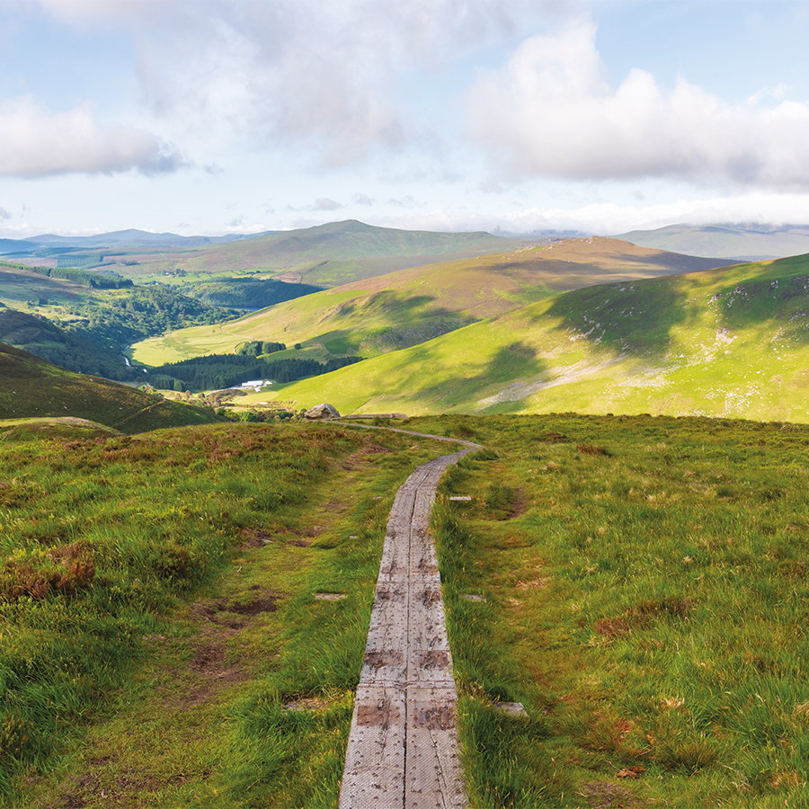
DIAMOND HILL FROM LETTERFRACK, CO GALWAY
DISTANCE: 3km–3.7Km
DIFFICULTY: Easy to moderate
TIME: 45 minutes-2 Hours
I love Connemara and I have spent so much time there racing and hill-walking over the years. This walk is in the Connemara National Park, beside the village of Letterfrack. Diamond Hill stands at 442 metres high– whether the walk is easy or moderate depends on the option you choose. Both walks start at the visitors’ centre, where you can also park.
There are two walks here to choose from: the 3km Lower Diamond Walk, and the 3.7km Upper Diamond Walk. Both walks are suitable for all levels and no special equipment is required, but in autumn or winter I would recommend proper footwear and a good rain jacket as it can get really cold and windy towards the top. Both routes are very well signposted, and gravel footpaths and wooden boardwalks guide you over the bog as you approach the mountain. Near the foot of the mountain, you can continue walking the Lower Diamond Walk or turn to tackle the Upper Diamond Walk. There is a steady climb to the summit but the magnificent view is worth it.
In fact, the views on both these walks are second to none. Diamond Hill looks down on Connemara National Park, Kylemore Abbey, Inishturk and Inishark and the Twelve Pins mountain range. The loop continues down the opposite side of the mountain, where you rejoin the lower walk. If you like, you can also complete that walk or you can head back to the visitors’ centre where you started.

INISHBOFIN WESTQUARTER LOOP, CO. GALWAY
DISTANCE: 5km
DIFFICULTY: Easy
DURATION: 2 Hours
Jump on the ferry from Cleggan pier in Connemara and you’ll soon find yourself on the small island of Inishbofin, which sits 8km out in the Atlantic. Large parts of the island are an Area of Special Conservation, which makes walking here a real joy.
Starting at the pier, the Westquarter Loop leads around the western section of the island, past blowholes and sea arches, cliffs, a beach and the haunting ruins of an Iron Age promontory fort. It’s an invigorating walk with great Atlantic views and a real feeling of isolation and escape. Heading back to Bofin Harbour, drop into the Inishbofin House Hotel for a late lunch in the bar before catching the ferry back to Cleggan.
SEE MORE: 5 Hotel Breakfasts To Enjoy In Ireland (For Non-Residents Too!)

PILGRIM’S PATH, SLIEVE LEAGUE CLIFFS, CO DONEGAL
DISTANCE: 2.8km
DIFFICULTY: Moderate
DURATION: 1.5 Hours
Wild, dramatic, majestic – the Slieve League Cliffs are among the highest sea cliffs in Europe, and if you’re looking for a walk that will take your breath away, this is it. Starting out steady, the path soon becomes rocky as it winds its way up to about 420 metres. Along the way, you’ll be treated to exceptional Atlantic views; racing skies, which can change from wispy blue to granite-grey in minutes; and craggy, rocky landscapes that tumble down to the sea. Bring suitable clothing and good footwear – the weather can turn quickly up here.

GOBBINS CLIFF PATH, CO ANTRIM
DISTANCE: 5km
DIFFICULTY: Hard
DURATION: Around 2.5 hours, guided walking
Wrapped around the sea cliffs of Antrim, the Gobbins is the only guided adventure walk of its kind in Europe. This incredible path snakes through dramatic tubular bridges and smugglers’ caves, and above crashing waves, and is a truly elemental experience. First opened in 1902 and designed by enterprising Edwardian engineer Berkeley Deane Wise, the Gobbins was reopened in 2015 and it remains as captivating as ever. From your first step through Wise’s Eye at the path’s mouth, you can’t help but marvel at the incredible engineering that brought this path to life over a century ago.
SEE MORE: A Travel Guide To Fermanagh And Down

The Walking Effect By Karl Henry is out now.